The
County Line Road
Location: The designated portion
of this road (Rte. 325) begins at Caledonia at the intersection
of Rte. 315 and runs north for 2.6 km until it intersects with
Rte. 317.
The name “County Line” derives from the fact that
it is on the boundary of the two counties’, King and Queens.
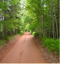
A drive through the County Line Road offers many vantage points
for viewing the surrounding countryside. Midway along the road
is a small but lovely hardwood stand. This road has been designated
as a scenic heritage road. In
earlier years horse-drawn carriages transported passengers
along this lane, at the time bordered by beautiful hardwood
stands that arched overhead to form delightful canopies. The
area has changed little over the years and the locals still
use this road as a shortcut to other areas.
The
County Line road derives its name from the fact that it is
on the boundary of the two counties, King and Queens. |
 |
The
Klondyke Road
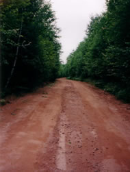
Location: For 4.9 km the Klondyke
Road travels roughly in an east-west direction from the Selkirk
Road (Rte. 23) south of Iona, to the Murray Harbour Road (Rte.
24)
Uphill and down, the Klondyke cuts a sturdy swath through
a border of sugar maple, birch and spruce. Foxes, squirrels,
raccoons, and hares have a secure corridor amid the trees
and lower vegetation, as they scurry from one woodland thicket
to another.
In
the early 1900’s, sawmills and several homesteads were
located here. Colonel Weatherbie, known in military circles
as the “Father of Canadian Munitions” due to his
experience in that field, was the last settler to live on
the road. His homestead, now abandoned, was once a welcome
retreat where visitors enjoyed the beautiful flower gardens
and the musical talent of the family.
The
prohibition of the 1920’s and 30’s set the scene
for another activity – rum running! Under the cover
of darkness, the rumrunners would steal along the darkened
road hiding their contraband in a secure place. A rag would
be tied to a tree indicating the hiding spot.
www.benslake.com |
 |